Scientists are very afraid of the Polar Vortex
In 2023, an organization that studies the atmosphere of our earth issued a warning that the temperature of the earth at the North Pole of the earth will decrease a lot due to which the temperature of the atmosphere has decreased a lot. Due to which, at the end of 2023, Canada, Europe and USA are going to get very cold and it will be the most dangerous winter till date.
Upcoming Cold Wave
Scientists say that the most dangerous cold wave till date will come at the end of 2023. A few years ago, 22 people died in the cold wave that hit the USA. This cold wave will be many times more dangerous than that cold wave. The lowest temperature was recorded in 2019. At that time, the ice cold wave covered 27 states of the USA with snow.
The hottest state in USA is Texas, the temperature here does not go below 40 degrees, in 2019 the temperature there fell to -18 degrees. This cold wave was so dangerous that the USA had to cancel its 500 flights. Due to which the USA had to suffer a loss of 950 Billion US Dollar. Such cold is seen only at the south pole and north pole of the earth, but the thing to think about is how so much cold came to the USA under the earth.
The Polar Vortex

At the poles of our earth there is always a storm rotating at the speed of 400 km per second which is called Polar Vortex. The gusting power of the Polar Vortex was measured eight years ago by the USA by dropping a bomb.
When the world war was starting in 1940, President Franklin Roosevelt wanted to build 50,000 warships, so he needed 10,000 trained officers. Carl-Gustaf Rossby, a scientist at that time, noticed that wartime bombs would miss their targets. These ships used to drop bombs from very high altitudes, which Carl-Gustaf Rossby thought might be due to the winds. When the Polar Vortex was detected in 1920. They felt that the ships were missing their target due to this storm. Carl created a mathematical model for dropping a bomb on its target, which showed that the Polar Vortex spins like a storm and affects the entire Earth’s weather.
These winds affect the entire weather of the earth, which is why it is called the Polar Vortex. The winds that affect the Earth’s climate are called Polar Jet Streams. These polar jet steams help propel the polar vortex forward and also help keep it in place. Sometimes the Polar Vortex becomes so strong that even Jet Steam cannot stop it.

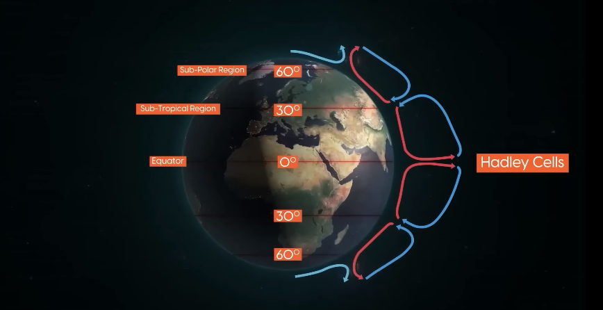
Sunlight falls directly on the Earth, causing the air in the Polar Vortex to warm up because the warm air weighs less than the cold air, which creates a low pressure zone at the Earth’s equator. The warm air starts moving upwards and after going up, this air cools and comes down again, then it collides with the cold air coming from the North Pole and South Pole. Due to this collision, the warm air coming from the equator moves towards the surface. Then this hot air is divided into two parts.
- The first wind that goes back to the earth’s equator due to which the earth’s circulation loop is also complete. Which scientists call Hadley Cells.
- The other wind that moves north meets the cold air of the sub polar region coming from there.

Both these winds hit the surface of the earth so they have to go down further but they have no place to go down so they start going up again. Due to which a low pressure zone is formed on the sub polar region just like it is formed on the earth’s equator. This rising air also divides into two parts.
- One of which flows back towards the south pole and collides with the wind coming from the equator in the sub tropical region. This circulation pattern is called Ferrel Cell.
- The second air flows towards the north pole and sinks. Due to this sinking air, a high pressure zone is formed there, after which this air flows towards southeast east, then collides with the rest of the sub-region and moves back towards the pole, it is called Polar Cell.

Due to this circulation, 3 regions are formed Polar Cell, Ferrel Cells and Hadley Cells. Due to these cells, a low pressure zone is formed in the sub polar region and a high pressure zone is formed in the sub tropical polar region. All these activities take place in the earth’s atmosphere. But the Polar Vortex forms in the boundary of the atmosphere.
Warm air passes over cold air which is why it should flow towards the east of the earth, why it flows towards the USA all because of our earth’s Coriolis Force.
Coriolis Force
Let me explain with an example. Suppose you are in a rotating swing and that swing is stopped and at that time you throw a ball towards your friend, then the ball will go directly to your friend. But when you throw the same ball from a moving swing, it will go in the shape of a curve, that is what we call Coriolis Force. Due to which the Polar Vortex also follows the same, due to the rotation of the earth, the hot air will rotate in the form of a curve instead of going straight. This wind rotates in the form of Polar Vortex. Due to which Polar Vortex is formed there
The Polar Jet Stream
Now coming back to Jet Stream it is very strong but sometimes their wall breaks.

Due to the breaking of its wall, the cold air of the optical region starts going into its region, which we call cold waves. Why does this happen? The temperature difference between the regions of the optical region and the equator is very high, so the Polar Jet Stream is very strong and does not allow the polar vortex to come out, but as soon as the summer starts in the north, the optic region starts to heat up. Due to which the temperature difference of optical and equator region is not much due to which Jet Steam starts to weaken and starts to flow in a wave pattern.
Snow has started falling in the USA and UK regions as the Polar Region is leaking. Previously, the Polar Vortex used to leak once every ten years, but the number has increased over the past few decades and is set to increase more in the coming years. In fact, due to global warming, the ice in the optical region is melting. So the real reason behind this is global warming.

